Timeline
- Duration: March 2024 - ongoing
- Partners: City of Redmond, Department of Public Works
- Status: In-Progress
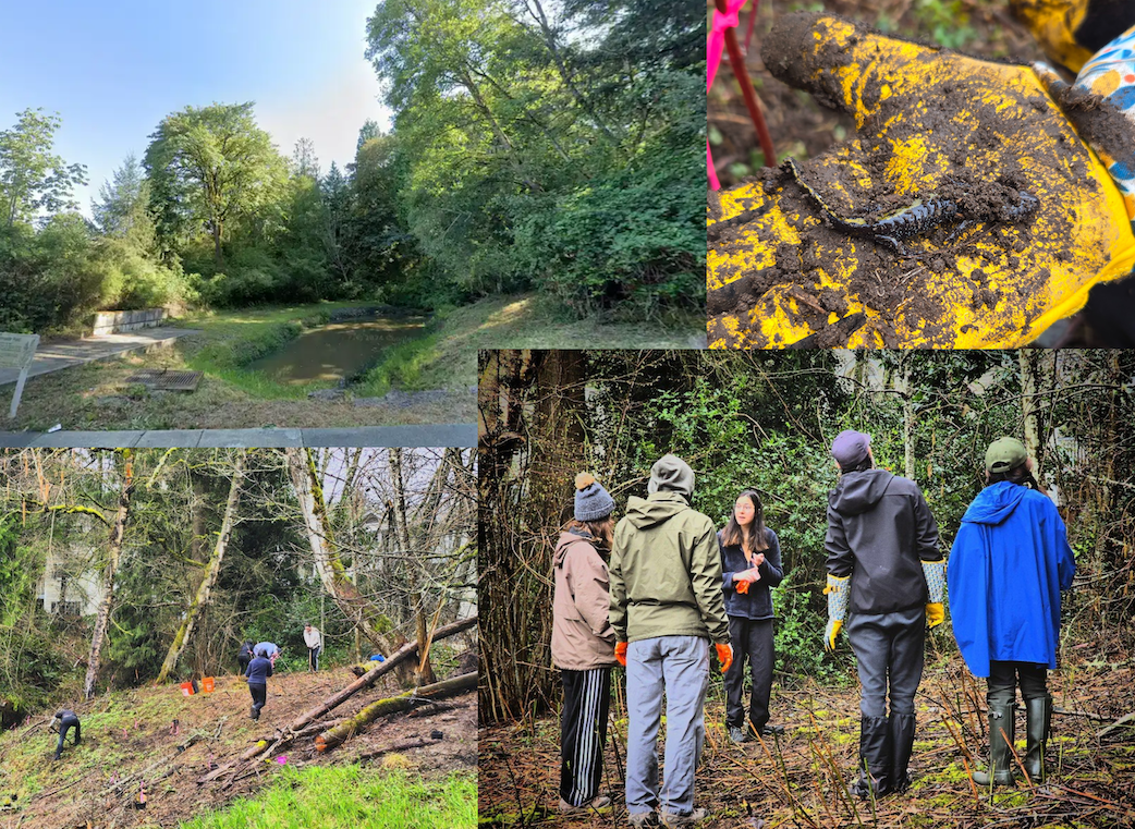
At the corner of 40th Street and Bel-Red Road, there is a stormwater pond that most people hardly notice at all. When I first stopped there, the sign was caked in dirt, softened by years of rain, quietly reading Stormwater Pond as if it were unsure anyone still cared. The pond itself was small, hemmed in by a dense and towering tangle of invasive plants—a dangerous duo of blackberry and morning glory that had claimed the edges entirely.
In one corner stood a tall Bigleaf Maple. I didn’t know it then, but it was home to a flicker. At that moment, all I could see was the potential: a beaming pond, open and alive, surrounded by native plants that could provide food, shelter, and habitat for the wildlife trying to persist in the middle of the city.
I reached out to the City of Redmond’s Public Works Department to ask a simple question: Can I get permission from the city to restore this place? To my delight, they didn’t just listen—they said yes. With their approval and guidance, the idea began to take shape, turning possibility into something tangible.
Support followed quickly. The Washington Native Plant Society donated native plants, helping lay the foundation for restoration. Eastside Audubon provided grant funding that allowed us to dream a little bigger and act more decisively. And then came the best part: the community through work parties I hosted and shared on Nextdoor to invite others to learn, contribute, and care.
Through work parties and volunteer days, people showed up.Neighbors, plant lovers, curious passersby. Together, we pulled invasive blackberry and morning glory, slowly giving the pond room to breathe again. We planted native species chosen for both beauty and function: water parsley along the wet edges, red osier dogwood for structure and winter color, penstemon for pollinators, and many others. Each plant felt like a small promise placed into the soil.
As we worked, we began documenting the life that was already there using iNaturalist. Birds, insects, and plants quietly revealed themselves, reminding us that this space had never been empty—it had only been waiting.
None of this would have been possible without the generous support of Tom Hardy, an environmental scientist whose knowledge, encouragement, and steady presence helped guide this project from idea to reality. His support made all the difference, and I am deeply grateful.
Now, as the plants settle in and the pond begins to change, we’re looking ahead. The next steps include working with the community to design educational signage, installing a bench so people can pause and linger, and—perhaps my favorite part—giving the pond a name.
In honor of its most steadfast resident, we’re calling it Flicker’s Pond .
This project has reminded me that restoration doesn’t always start in sweeping landscapes or distant wild places. Sometimes it begins with noticing. With stopping at a street corner. With seeing potential where others walk past. And with inviting a community to come together and care.
Flicker’s Pond is still becoming. And so are we.